The Yanomami indigenous tribe has been battling the devastating impacts of illegal mining for decades.
This unlawful practice has wreaked havoc, causing deforestation, mercury contamination in rivers, the proliferation of diseases, and tragically high mortality rates among the Yanomami people.
Despite efforts by the Brazilian government and international bodies to curb these activities, the problem persists.
In this blog, we'll provide some context of the situation and take an in-depth look into the progress achieved by recent initiatives taken by Brazil's current government.
A Little Background
The Yanomami Indigenous District stands as a vital sanctuary within the Amazon rainforest, nestled in the Brazilian state of Roraima, safeguarding its rich biodiversity and cultural heritage.
Tragically, the tranquility of this region was shattered in the early 1970s when the discovery of gold within the Yanomami territory enticed a wave of small-scale independent gold miners, locally known as 'garimpeiros.'
However, the situation took a devastating turn during the 1980s when an estimated 40,000 Brazilian gold miners invaded their land, subjecting them to violence, destroying their villages, and exposing them to diseases to which they had no immunity. Shockingly, within a mere seven years, this onslaught led to the loss of approximately twenty percent of the Yanomami population. (Source: Survival International)
In the face of this harrowing crisis, Brazilian authorities and international organizations have made concerted efforts to address the situation and restore justice. Yet, despite these endeavors, the invasion of Yanomami land by gold miners persists, fueled by intricate political, economic, and social dynamics.
Using Satellite Imagery to Combat Illegal Mining
Given the vastness and remoteness of the Amazon rainforest, traditional methods of monitoring such activities are insufficient. Enter satellite imagery analysis.
This technology has revolutionized how we understand and respond to illegal mining, especially in places like the Yanomami territory.

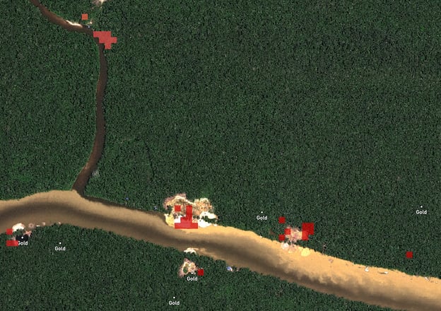
Source: Maxar
Satellite imagery provides a bird's eye view of the ground situation, allowing for the identification of new or expanding mining sites.
It enables constant monitoring of vast areas, irrespective of geographical obstacles or political boundaries, making it an excellent tool for tracking the progress of illegal activities over time.
Satellite imagery also plays a crucial role in evidence collection, providing tangible proof of illegal mining activities that can be used to spur legal and policy action.
Limitations of Satellite Imagery Analysis
Despite its advantages, relying solely on satellite imagery to tackle illegal mining has limitations. Cloud cover, prevalent in the Amazon, can obstruct clear ground views.
The imagery's resolution might not always be high enough to distinguish small-scale mining activities.
Furthermore, it can show that mining is taking place, but it cannot provide real-time information about who is conducting the mining or their movements.
Moreover, satellite imagery is a reactive solution; it identifies a problem after it has occurred.
As such, it doesn’t preemptively stop illegal activities but helps document the destruction after the fact.
Geolocation Intelligence: A Complementary Approach
Given these limitations, it is worth considering a complementary solution: geolocation intelligence. This technology uses data from various sources, like mobile devices and social media, to understand and predict human behavior in specific locations.
Geolocation intelligence provides insights into human activity in remote areas, including the Amazon. It can identify movement patterns suggestive of illegal mining, allowing for faster intervention.
This tool can also track illegal miners' supply chains, helping to pinpoint the people and systems that support these activities.
Geolocation intelligence can offer a more proactive solution to illegal mining than satellite imagery analysis. It can detect and predict unusual activity before significant damage is done.
It also overcomes some limitations of social media monitoring and field research, often restricted by connectivity issues and safety concerns in remote areas.
Investigators looking to use such remote sensing techniques should be mindful of complying with data privacy regulations and only work using anonymous or non-personally identifiable geolocation data harvested with user consent.
Data privacy-focused suppliers like AKTEK can help you facilitate compliance through double obfuscation, irreversible hashing, and GDPR request management.
Change in Government, Change in Policy:
Measuring the Impact
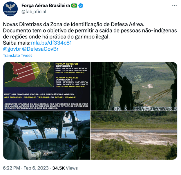
Earlier this year, newly appointed President Lula pledged to eliminate illegal mining, announcing a significant offensive against minors that started in February, closing the airspace.

Source: Forca Aerea Brasileira
Justice Minister Dino was reported to say he expected as much as 80% of the illegal miners to have left by the first week of February.
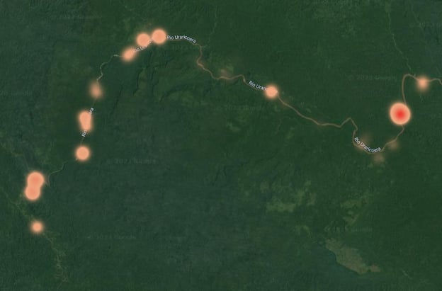
Monitoring the issue using anonymous geolocation data, AKTEK observed a decline of approximately 18% in mobile phone activity in the protected area suggesting some positive impact but not complete eradication of the issue.
News reports show the task force at work, destroying machinery and equipment but often finding no one at the sites they visit.

Source: AKTEK iO
Our evidence suggests that illegal miners, who had chosen to remain in the Yanomami territory despite the task force being deployed, retreat when they know state actors are coming but they do not abandon the territory completely.
They come back and resume activities where they can. Satellite imagery might not detect much change, as observing impacts on the territory takes time, but geolocation data can give us a closer to a real-time view of actual activity on the ground.
Conclusion
Satellite imagery has undeniably been a game-changer in the long struggle against illegal mining in Yanomami territory. Yet, its inherent limitations underscore the need for incorporating additional data sources such as geolocation intelligence.
By synergistically deploying these technologies, we can enhance our ability to track, understand, and even predict illicit mining activities to control them better.
This integrated approach is the key to enhancing our odds of preserving the Yanomami people's way of life and protecting the priceless biodiversity of their ancestral lands.


.jpg?width=300&name=Blog%20Link%20Preview%20Image%20(25).jpg)
